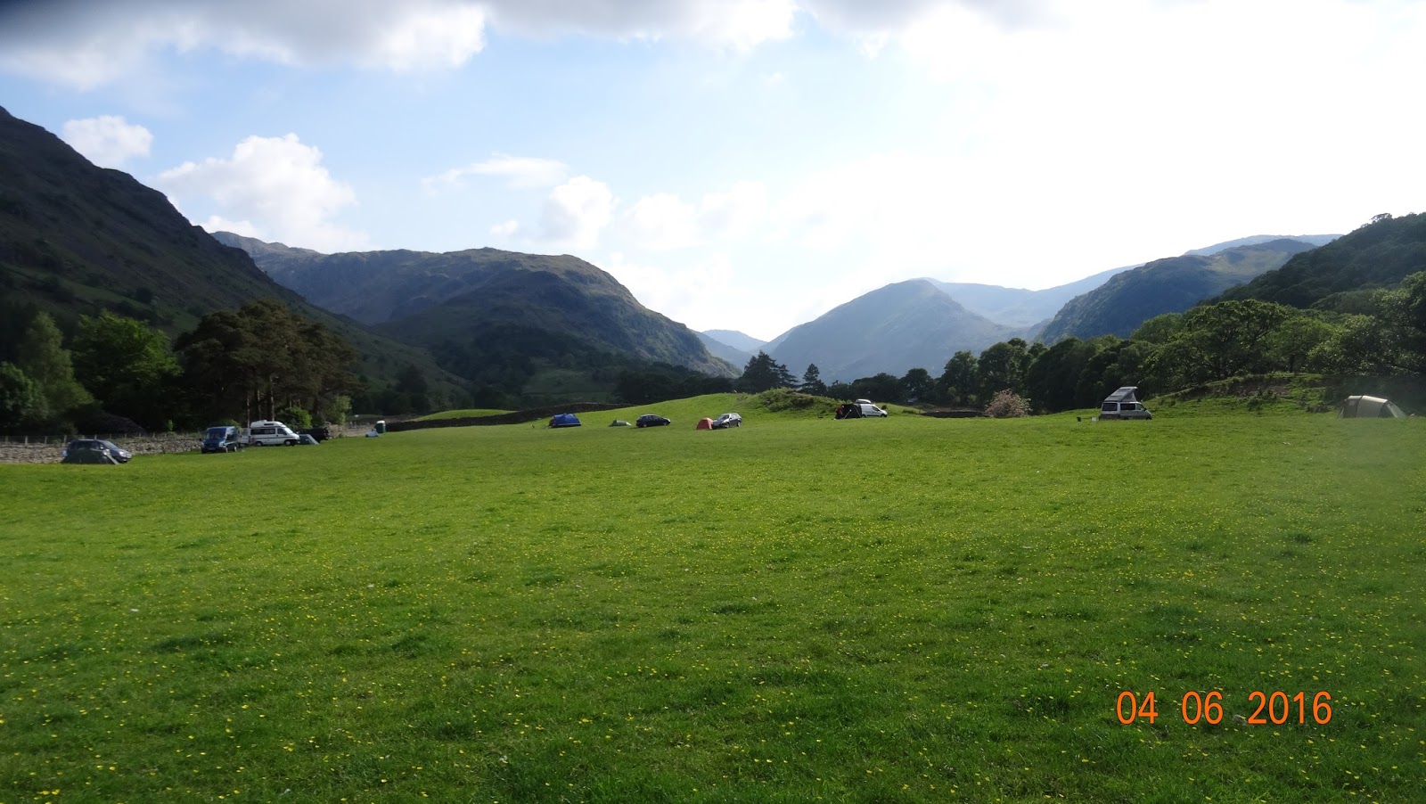
Another last minute decision saw us drive up to BORROWDALE in the Lake District for a camp out and a walk up to CASTLE CRAG. Although I have been here before, it's a first for Jill and we were blessed with good warm sunny weather for the most part. We didn't leave home till after midday and arrived at the campsite about 3.30pm, got the tent set up and had a walk round the tiny hamlet of Rosthwaite, where the home made ice cream is very nice :-) and down to the River Derwent that runs along the field where the campsite is. A beautiful place surrounded by some of the high Lakeland fells.
Campsite surrounded by the fells
Oh, the joys of camping :-)
Hamlet of Rosthwaite. Ice cream shop is the last cottage where the sign is
Lovely :-)
The walk up to Castle Crag on the Sunday was at a leisurely pace as we were in no rush to leave and as it was a there and back of four miles, no need to rush. It was warm, very warm and a bit muggy as the blue sky of the morning was disappearing and it was very hazy. The route was straight from the tent, across the river by the National Trust campsite and up through Jonnys Wood & Scaleclose Coppice. There should be a waterfall at Scaleclose force, but as there was little or no water in the becks and rivers, no waterfall!!! Oh well, we imagined it instead and it looked good :-)
(As my camera battery had almost died, most photo's are of my phone)
Our route for the walk
Castle Crag from Jonny's Wood
On the way to Scaleclose Coppice
The foot bridge over the very empty Scaleforce Beck
The very empty Scaleclose Force waterfall
There should be a waterfall but as you can see by the rocks below, the beck is empty
Out of the Coppice and up to Tongue Gill where a few paths meet up going in all directions leading to the surrounding fells. I'll get back here sometime for a good look round one weekend as it seems quite interesting with old quarries dotted about.
Castle Crag getting nearer
Wooden bridge over Tongue Beck, although it really wasn't needed today
View back down to Borrowdale from Tongue Beck
The path is very straight forward to follow and the only real steep/ tiring bit is the ascent up the old slate spoil heap. It looks impossible to climb but there is a zig-zag path going up the the top. The actual summit is a further 2 min climb up among some tree roots to the level platform the offers great views down on Derwent Water, across to Rossthwaite Fell and back down to Borrowdale. There is also a memorial on the summit for the men of Borrowdale who lost there lives in World War 1
The slate spoilheap with the zig-zag path on the left
View down to Borrowdale from the top of the spoil heap
View up to the summit from the spoil heap
Slate quarry pit
Summit War Memorial
Taking in the hazyview down to Derwent Water
Hazy summit view down to Jonny's Wood
Hazy summit view down to Derwent Water
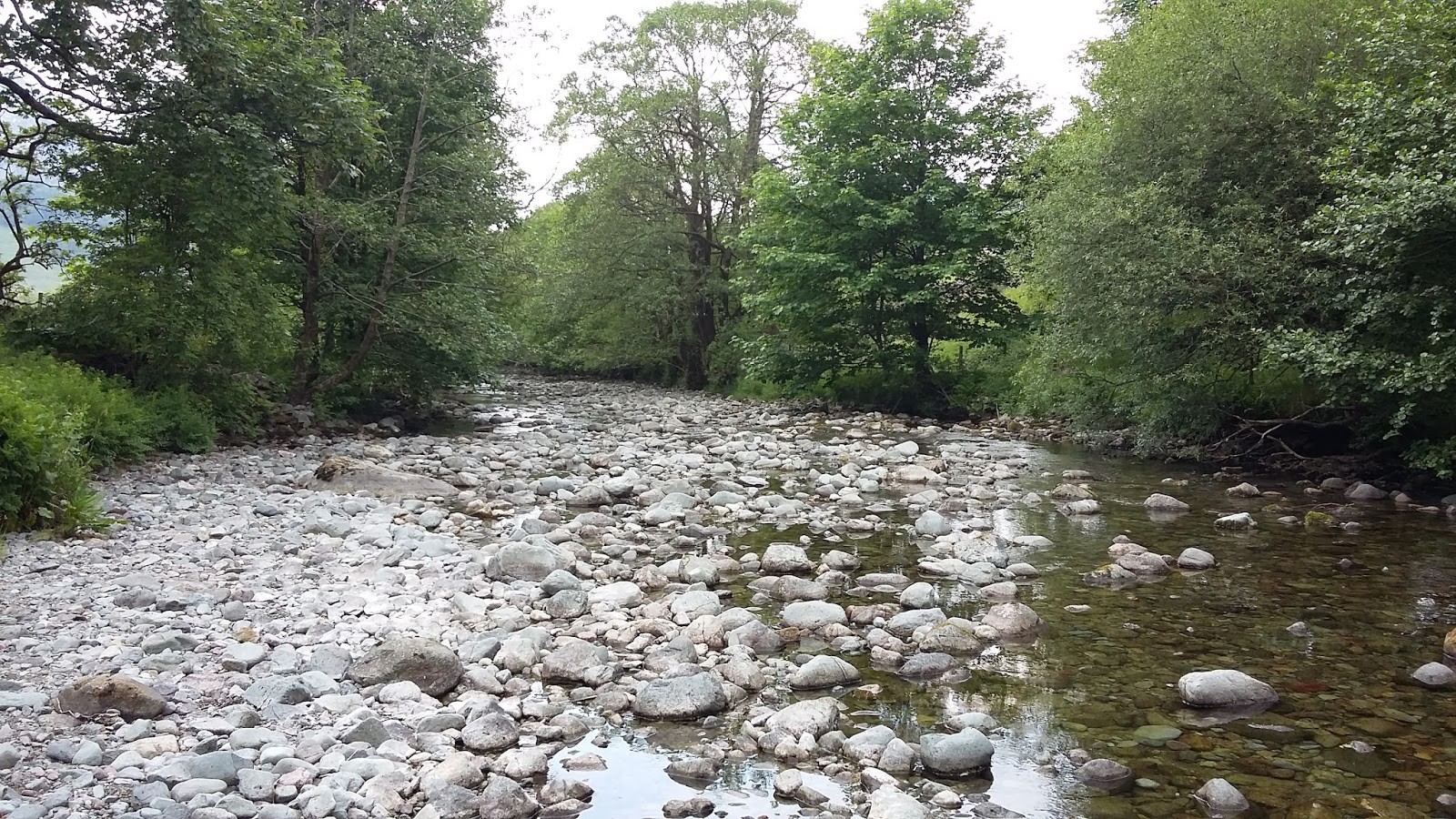
After about half an hour we made our way down the steep ascent that brings you on the banks of the River Derwent or what should be the River!!. More like a dry river bed with the lack of rain over the last few weeks. There was water and we even spotted a few fish in some deeper pools but on the whole it was really lacking in water. We did pass a bridge that had a sign and some barriers on it warning people to take care on the bridge as it had been damaged by the winter floods. Fromone extreme to the other!
Looking back at the descent path through the woods
Warning sign on the damaged bridge
Damaged bridge over the empty river
Empty River Derwent
Empty River Derwent
Who nicked all the water!!!
A straight forward walk back to the campsite ended another great day out in the Lake District. Great campsite, great weather, great walk and excellent company :-)
Well another bank holiday walk in this very quiet and wilder side of the Carneddau Mountain area of Snowdonia. I first did this walk three years ago, (View Here) again on a very quiet warm and sunny May bank holiday and today's walk was a repeat of that day. Sunny, warm, a bit cool on the tops and very very quiet. Infact it was quieter that the previous visit as I only saw one other person on my route all day and he was going in the opposite direction. Considering all the cars parked in the different car parking areas around this part of Snowdonia, it was eerily quiet apart from the Cuckoo making it's call all day. Unlike three years ago I didn't get to see one this time but it or they were certainly making there presence felt, a great sound of spring. Another difference of this walk is that I decided to take a different path up to the first summit of the day, Crimpiau, and take in the gentle climb up to Llyn y Coryn, a small lake nestled a the foot of Crimpiau.
I left the car park in Capel Curig and headed across the A5 and over the stile following the good path through a field, then the woods under Clogwyn mawr and to a small wooden bridge over a stream. From here I headed away from the bridge and upto a col following a faint path and sheep trails. Some great views back towards Moel Siabod and the Snowdon Massif were to be had.
My Route For The Day
Morning View Of Snowdon from Plas y Brenin
Looking back to the start of the walk
Well laid out path through the woods
Clear view over to Moel Siabod and a distant Snowdon
My route from the bridge up to the col
Looking back down from the col
I soon reached some outlaying outcrops of rock that I couldn't resist having a play on, infact a lot of this walk gives you the chance to have quite a bit of cheeky scrambling if you fancy it. Nothing hard, just a bit of fun on the way and also a good way to keep your feet dry as it can be a bit boggy in places. In fact it was quite boggy between the various tops so it was a good excuse to put hand on rock which is always a good thing :-)
First bit of outcrop to get warmed up
View down to Llyn y Coryn
Llyn y Coryn and my route ahead
From Llyn y Coryn I headed up some more rocks and the views started to open up with Moel Siabod, Snowdon and the whole of the Ogwen Valley laid out in front of me. a great sight on this blue sky day as I made my way up to Crimpiau and the splendid views down to the excellent Llyn Crafnant
Pano of Moel Siabod, Snowdon & Ogwen Valley
Another short sharp rocky scramble
A look back on my route from Crimpiau
Pano across to Craig Wen, Creigian Gleision & down to Llyn Crafnant from Crimpiau
After taking in the views and silence, apart from the cuckoo's, it was a steppish descent and then a steepish ascent as I made my way up on to Craig Wen, again taking advantage of the rocky crags of Castell y Gywant to get in more easy scrambling. From Graig Wen, it was up and over a couple of nice little scrambles that took me over Moel Ddefaid & Craiglwyn. It was turning out to be quite a fun way of keeping my feet dry as this part of the walk has more than its fair share of boggy ground. Not too wet to go knee deep but as I only had walking shoes and no boots I didn't fancy finding any bog monsters!
Looking back to Crimpiau
No Cuckcoo but I did manage to spot a Rock Pipit
The rocky face of Castell y Gwynt
Looking back down Castell y Gwynt
Summit view down from Castell y Gwynt.
Nice little scramble up to Craig Wen
A cheeky scramble
Craig Wen
Moel Ddefaid
Craiglwyn Summit
From here I made my way forward to the highest summit of the day @ 678 m (2,224 ft) Creigiau Gleision, again doing my best to avoid any boggy patches. Some great views to be had all round on this great day. A little hazy in places but a great day to be out.
Summit view of the Ogwen Valley and Llyn Cowlyd
Summit view of my route so far
Summit view of my route ahead to the North Summit
The North summit is slightly smaller @ 634m (2,080ft) but still has some excellent views, especially down to the dam on Llyn Cowlyd.
Llyn Cowlyd has a 45' (14m) high dam at its north-eastern end, which
consists of a rock and earth embankment with a concrete core. A concrete
and stone apron protects the dam from wave action, which comes from the
direction of the prevailing winds. The dam, which was built some 300
yards (274m) downstream of a lower, earlier one, was completed in 1921,
and was officially opened on 20 September 1922.
During construction of Cowlyd dam, electricity for the winches was
provided by the North Wales Power and Traction Co. Ltd's power station
at Cwm Dyli, near Snowdon. The remains of the pole route along the western shore of the lake can be seen today.
Stone for the dam came from an adjacent quarry, some ¼ mile to the
north of the dam site. A short incline was constructed for transfer of
stone, and it ran directly from the quarry down to the dam. Remains
today suggest that this was poorly constructed, but its line is easily
followed, and is clearly evident from, for instance, the summit of Creigiau Gleision. A later vehicle route also winds from the dam to the quarry. Remains of the winding drum can still be seen.
Construction workers lived in wooden barracks, a number of which
afterwards found their way back to the Trefriw and Dolgarrog area to be
converted into homes, and are still lived in.
North Summit
North Summit view down to the dam
An easy path to follow brings down to the shore of Llyn Cowlyd where a 2 mile walk along the shore line brings you to the southern end of the lake. Looking back it its a great view with Creigian Gleision on one side and the bulkier Pen Llithrig y Wrach on the other side. There was also the added bonus of a few of the Carneddau Wild Ponies on my path and one that looked in need of having his hooves seen too. Not sure if he was in pain or not but despite the condition he seemed to be coping OK.
View of the summits of the day
Llyn Cowlyd with Creigiau Gleision on the left and Pen Llithrig y Wrach on the right
Pipe line out from Llyn Cowlyd
Creigiau Gleision above Llyn Cowlyd
Wild Carneddau Ponies
Overgrown toe nail, ouch
Looking down back Llyn Cowlyd
A straight forward and pleasant walk back to the car ended what was yet another great day out in this very quiet part of Snowdonia. The views were now getting a bit hazy and the cuckoo seemed to have disappeared after calling out the most of the day.